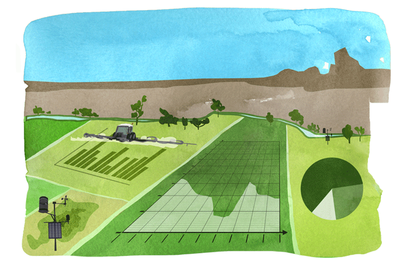
Smart Agriculture
In agriculture, first with the application of cross-compliance in the CAP, and later with the growing diffusion of a digital approach in management and operational activities, the already consistent use of meteorological information has evolved towards the need for clear and reliable meteorological-climatological data. In agronomic activities, in agrometeorology and in precision agriculture, the availability of consistent and representative weather data allows the optimisation of choices, actions and therefore the results, through application of modular and proportionate responses to specific situations, with benefits in terms of effectiveness, resource savings and environmental impact. The detailed meteorological information also contributes to feed other applications and processes, such as decision support systems, the definition of vegetation indices, IoT (Internet of Things) solutions: all this can be defined as ‘smart agriculture’.
Solutions
AgroCast®
The service which, by using historical, near real-time and forecast meteorological datasets, at high resolution and spatialised on territorial grids at a global level, continuously fuels company decision-making systems in agriculture.
 The meteorological data provided by the system can contribute to the operation of decision support systems, the elaboration of plant status indices, IoT solutions for the automatic activation of agricultural tools (e.g. precision irrigation).
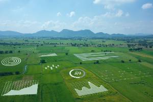
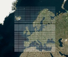 Weather datasets are organised on continuous and regular grids for complete coverage of the globe. Each cell of each grid operates as if it were a virtual weather station and a continuous flow of historical, near real-time and forecast data or a combination of them is linked to it.
 In agronomic activities, and in particular in precision agriculture, the availability of reliable and consistent weather data allows to optimise choices, actions and therefore results, through application of modular and proportionate responses to specific situations, with benefits in terms of effectiveness, resource savings and environmental impact.
MeteoCast®
The interactive web platform in which all operational weather services and products are integrated; it is easy to consult and provides immediate, global, and shared information on current weather events and their evolution, to facilitate decision making even in complex organisational contexts.
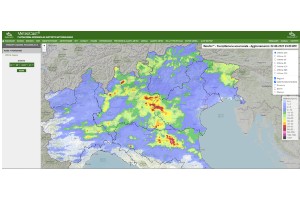 Access to the platform allows the user to obtain a complete and real-time overview of the state and evolution of the weather situation; the user can view radar weather data, ground weather station data, forecast models and other Radarmeteo services. All on the WebGIS system.
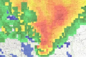 Weather radar has the function of detecting atmospheric precipitation (rain, hail, and snow) in real time. Radarmeteo collects the data detected by the various national radars and integrates them into the dedicated mosaic; has also developed the Nowcasting functionality for short-term forecasting.
 The platform and related services are optimised for access from all mobile devices (smartphones and tablets), allowing quick and mobile consultation of weather data.
Design and certification of weather networks
The service supports the customer in designing from scratch or remodelling of the meteorological networks and their adaptation to WMO standards; it also provides the necessary support to achieve certification of weather networks.
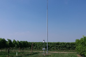 Often the networks of meteorological stations, due to situations or problems that are sometimes easily overcome (suboptimal location of the station, lack of correct validation of the data, inadequacy of some sensors) produce data with low reliability. Radarmeteo supports the customer in the design and installation phases or in the possible adaptation of existing weather networks.
 Once completed or at the end of the adaptation process, the meteorological network can be certified by a third party, independent and authorised. According to WMO guidelines, the certification process involves every single station that makes up the meteorological network. Radarmeteo supports the customer during the process and on-site verifications.
 The daily control of weather data quality is what allows the user to identify the malfunctions of the weather stations more quickly. Radarmeteo implements the data quality control system, by sending timely alerts in the event of ascertained anomalies
REFERENCES
Customers who support our growth
Radarmeteo collaborates with companies of different sizes and with different organizational characteristics, adapting the services and the business model to the requests of the interlocutor. This allows at the same time a very lean relationship, dedicated to the identification of ad hoc solutions, and maximum customer satisfaction.