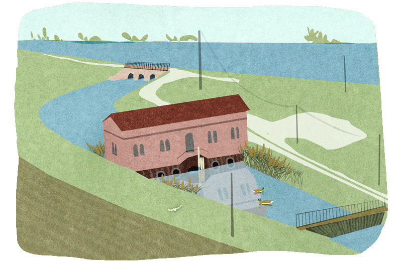
Land reclamation authorities
The Land Reclamation and Irrigation Authorities still represent one of the cornerstones of territory protection and management, both for the traditional reclamation action and, above all, for the maintenance of areas now occupied not only by agriculture but also by residential and economic activities. The Land Authority is technical body in charge of design and implementation and it maintains the deep knowledge of a territory at times forgotten by its inhabitants. Following growing environmental awareness, they are now protagonists in many of the projects that have redesigned rural territory, with the aim of reducing water resources usage and mitigating the impact of pollution of agricultural origin.
Radarmeteo offers a series of operating platforms that allow precise knowledge and control of meteorological events, providing a concise and immediate view, as well as analytical and in-depth insights. These tools are user-friendly, accessible and designed to be integrated into the various activities undertaken by the authorities.
Solutions
MeteoCast®
The interactive web platform in which all operational weather services and products are integrated; it is easy to consult and provides immediate, global, and shared information on current weather events and their evolution, to facilitate decision making even in complex organisational contexts.
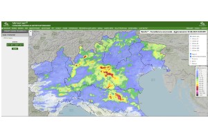 Access to the platform allows the user to obtain a complete and real-time overview of the state and evolution of the weather situation; the user can view radar weather data, ground weather station data, forecast models and other Radarmeteo services. All on the WebGIS system.
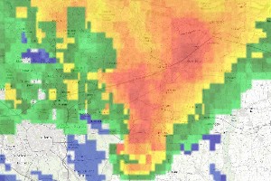 Weather radar has the function of detecting atmospheric precipitation (rain, hail, and snow) in real time. Radarmeteo collects the data detected by the various national radars and integrates them into the dedicated mosaic plot; has also developed the Nowcasting functionality for short-term forecasting.
 The platform and related services are optimised for access from all mobile devices (smartphones and tablets), allowing quick and mobile consultation of weather data.
RainGis®
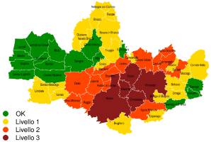
The service that displays on an interactive map the georeferenced pluviometric data of accumulated precipitation (rain and snow) for the entire national territory, integrating the radar measurements with those coming from the meteorological stations present on the ground.
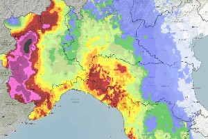 The service provides an extremely clear and updated representation in real time (every 60 minutes) of the distribution of rainfall of the last 72hrs and their measurement in mm. All data are also historicised, archived and therefore available for the analysis of past events and weather data.
 The RainGis® algorithm integrates the pluviometric data of the meteorological stations installed in the area and the data of the approximately 40 radars present throughout Italy and the neighbouring countries, which allow uniform coverage of the national territory.
 In addition to map visualisation, the service allows the user to view and export data in graphic/table format, or to directly integrate the output of the algorithms into the customer’s systems/platforms (e.g. DSS for flood forecasting) through dedicated APIs.
RainCast®
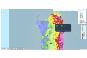
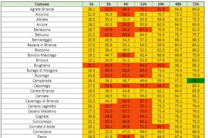
The weather service that allows the user to obtain quantitative, detailed, and updated information every 60 minutes on the precipitation accumulations expected in the next 72 hours, relating them to the climatology of the territory.
 The algorithm at the base of RainCast® provides, with hourly updates, the detailed forecast of the precipitation accumulation on the zone of interest for the next 72 hours, specifying the expected quantities in the requested time windows (e.g. 1, 3, 6, 12, 24, 48, 72hrs).
 RainCast® provides a more accurate quantitative estimate of predicted precipitation compared to standard forecasting products thanks to the integration of modelled weather data with nowcasting data from weather radar.
 The quantitative forecast information is correlated to the histories of the precipitation events of the monitored area, thus also providing a territorial contextualisation and allowing the completion of information with other important parameters (e.g. the return period of the forecasted event) to understand the intensity of the upcoming event.
REFERENCES
Customers who support our growth
Radarmeteo collaborates with Land Reclamation Authorities of different sizes and with different organizational characteristics, adapting the services and the business model to the requests of the interlocutor. This allows at the same time a very lean relationship, dedicated to the identification of ad hoc solutions, and maximum customer satisfaction.